
speed up projects; reduce health and safety issues; get ahead of competition, BUT knowledge of how, why and what is essential.
 The closure of Gatwick airport for three days, from 19th to 21st December 2018, grounded 1,000 flights and affected over 140,000 passengers. It is sadly this bad publicity that qualified and professional drone operators need to overcome. These were, however, all down to recreational operators who showed a complete disregard for safety and for others. Regulations, licenses and enforcement changes are afoot, but still domestic use regulatory requirements will be far less stringent than those imposed on commercial operators.
The positive impact drones have had need to be highlighted much more; there are so many benefits of drones, but these always seem to get less publicity. In fact, the Government itself cited reports from PWC which estimated that by 2030 drone use could save £16 billion, and that there could be as many as 76,000 commercial drones in our skies by then. Such saving needs to be taken seriously.
Why use drones in construction and property?
The use of data capture from drone technology continues to increase in the UK and Irish construction industries, with 52% of respondents now using the technology compared with only 33% in 2017, according to a recent survey by aerial mapping specialist ProDroneWorx.
The survey asked 150 senior figures within the construction, infrastructure and asset inspection markets about their perception, usage and understanding of the technology. It found that the three main reasons for adopting the technology are; improved data quality (56%), time saving (54%) and the reduction of risk (42%).
Drone technology is currently being under-utilised, according to ProDroneWorx. While 74% of respondents are using drone technology for photography and video, fewer than 30% of them are using it for value-added services like aerial light-detection and ranging (LiDAR), 3D point clouds, 3D modelling, digital surface/terrain models, orthophotos and thermal imaging.
Positive Drone Uses
We already see the police and rescue services using drones. This is much quicker and represents a lower cost than using a helicopter, although these are still mostly used today. The Government reported that between May 2017 and April 2018, 68 saved lives can be directly attributed to drone use. Many stories appear in local press about the overwhelming success of search and rescue operations using drones.
- Buxton Mountain Rescue received permission to use drones for missing persons, which has been a real success.
- AT&T used the ‘Flying COW’ to provide emergency 4G coverage to Puerto Rico in the aftermath of Hurricane Maria in November. Each drone was able to cover an area measuring 36 sq km. As a result of this Nokia wants to take things a step further and turn police vans and fire engines into command and control centres, to help emergency responders make crucial decisions much faster than they do today. Nokia is testing out the technology with Vodafone and firefighters in Dusseldorf, Germany.
Thorsten Robrecht, Nokia's vice president of advanced mobile networks solutions has said: ‘You don't need to send firemen into the hostile environment, if we use drones, we will have full situational awareness immediately."
- Africa needs mapping but, historically there has not been the resources to be able to address this changing landscape and population shift, however, the use of drones is radically changing this. In Ghana, a current project is mapping the positioning of bridges. What we will now be able to understand about this vast continent is better as a result. This will help aid and sustainability far more than ever before.
- Innovative drone technology has been developed to both identify and detonate landmines. This means that detection and detonation can be done from a safe distance.
- Finally, drones have been used for traffic control to gather real time information on traffic and congestion.
The construction industry
Drones have so many uses in the property and construction industry, from selling your home to building a new airport to developing a railway. The use of drones cuts down so much time and costs it cannot be ignored.
Drones can cut down surveying times to hours instead of days. They can also provide your business with accurate, up-to-date information in respect of your site’s progress and productivity, and they’re generally cheaper than traditional survey equipment. These also reduce health and safety risks, and as technology improves, we can predict and avoid disasters on multiple levels.
Data from multispectral remote sensing drones provide essential feedback on the health of plant life, fields and vegetation. Multispectral sensor data can detect problems from pests, disease, invasive weeds and stress to greens, fairways, rough, shrubs and trees long before the naked eye will notice. In fact, drones are also able to plant new trees and assist with areas of reforestation. The drones can now become a Remote Sensing Platform, using sensors and specialized software to create data and maps on the health and vitality of the plant life.
Large projects such as bridges, roadways and pipelines require hundreds of workers to be able to complete. Construction workers, managers and engineers must work in unity to complete large projects on time and under budget.
Getting an accurate picture of a construction site can be difficult with large projects. UAVs are the solution. UAVs with lidar sensors are already being widely used on all large construction sites.
Within the next few years the following are anticipated:
* Corridor mapping: power line, railway track, and pipeline inspection
* Construction site monitoring
* Building and structural inspections
* Surveying of urban environments
* Resource management
* Hydrodynamic modelling
* Digital Elevation Models
Drones have also been used positively for pest control in Ecuador, but it has a much wider application.
Drones to Inspect Masts and Buildings
The historical way of inspecting many different things has resulted in human injuries and death. Many injuries and lives have been lost every year when scaffolding collapses or someone falls off while inspecting a building or roof. In the Netherlands a report was released showing that they were over 100 deaths just from inspecting Telecoms masts over a 5 year period.
Further inspecting buildings and masts manually is costly, time consuming and hazardous, drones can reduce all these components. In fact, reports show that offshore wind turbine inspections have been reduced to less than 20 minutes.
Using drones instead of using workers to climb these masts for inspection will save a lot of lives and prevent injuries to workers.
Drones for Surveying Pipelines and for Highway Maintenance Drones
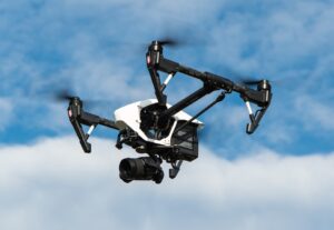
Such as the DJI Mavic, DJI Phantom 4, DJI Inspire 1, DJI Inspire 2 and Yuneec Typhoon H can obtain high quality aerial pictures and video of road surfaces, so that engineers, construction workers, and project managers can get an accurate picture of road conditions. There is no doubt that drones, quadcopters and multirotor will play a huge part in our lives from now on in.
The regulations and law
Drone technology has developed at such a rapid pace in recent years that the regulatory framework controlling their use has failed to keep up, especially in commercial applications.
Commercial drones are expensive, can be complex and highly versatile tools; they are often large and capable of travelling long distances at speed.
The physical risks, privacy and misuse are all clearly issues in the industry is currently facing. Long before the chaos at Gatwick and Heathrow, new regulations were already on the horizon concerning the use of drones, but this has created even more attention and need.
The new regulations, which come into force on 30th November this year, will introduce new safety measures, including the requirement that all drones weighing over 250g are registered with the Civil Aviation Authority (CAA) and that all operators take an online safety test to prove that they understand UK safety, security and privacy laws.
The new rules will without a doubt create a new, much-needed framework but are unlikely to be the end of the matter. They will apply to both professional users and hobbyists.
Following the events at Gatwick and Heathrow, it was announced that the police will also be given greater powers to deal with the misuse of drones including, the right in certain circumstances to take over and land a drone and the right to seize drones and review any stored data.
The police will also have the power to demand that users produce valid documentation, proving their right to operate the drone as well as evidence of its proper registration, just as they currently do with car drivers. The police will also be able to issue fixed penalty fines for some minor offences such as failing to land a drone if asked by a police officer or failing to show proper papers.
It is anticipated that most of the growth in drone use will be driven by business, rather than consumers and construction is one of the fastest-growing applications for drone technology.
Since 2010, anybody using a UAV commercially needs to be properly trained and issued with a Permit for Commercial Operation (PfCO) by the CAA. Exactly what constitutes ‘commercial’ usage is somewhat vague: CAA defines it as “any flight by a small unmanned aircraft…in return for remuneration or other valuable consideration”.
The new regulations coming into force in November are in addition to existing laws governing drone use. It is already illegal to fly a drone higher than 400ft (122m) or within 500ft (152m) of built-up areas and drones must remain within direct sight of the user at all times.
Such restrictions are a frustration for construction industry users who might want to shoot aerial footage of a busy site, survey a city-center building or take a look inside or behind a structure.
What the law says
UK airspace is regulated by the CAA (Civil Aviation Authority). In the ANO (Air Navigation Order) it covers specific guidelines on how drones should be operated. Due to the recent events it has since amended these guidelines and created a drone code to make them easier to understand.
Currently anyone operating a drone in the UK must:
- Keep their drone in sight, this poses the problem for those wishing to fly into buildings, pipes and tunnels for example.
- Stay 150ft (46m) away from people and buildings if the drone is equipped with a camera
- Keep 500ft (152m) away from crowds and/or built-up areas if the drone is equipped with a camera
- Avoid flying over, or within 150ft (46m) of, open areas with more than 1,000 people present and 1km away from any airport boundaries
- Adhere to all local authority rules about drone flights in the area, check air traffic control requirements and other bodies applicable to the areas you are operating within
- Only fly the drones as and when it is safe to do so – so, this emphasises the importance of documented pre-flight check lists and risk assessments
- Have suitable insurance in place – pilots must have Permission for Commercial Operations (PfCO) from the CAA. Ensure between you at the on-set whose insurance applies to what, if there is a conflict, and an issue arises this could cause business disruption and loss. The rules governing this are shown at EC785/2004.
Every commercial drone operator who has PfCO, is issued with a document granting the permission and setting out conditions for its use. Just for information an application fee is £247 following completion of your training at a CAA approved UAV academy, obtaining a qualification like a drone license, this can cost around £1000 on average depending on where you choose.
Have a proper risk assessment in place (this is you defence for everything)
It is also important to monitor employee compliance.
So, you also need to consider who is carrying out the risk assessment; how is this documented and who is checking this for the business to be covered and for insurance to be valid?
This is a consideration for the pilot; the employer and/or the client if brining in the resources.
Understand your responsibilities under the General Data Protection Regulations (GDPR), especially if you are using a drone to monitor performance
GDPR and privacy will form part of the risk assessment, but you need to consider where your business policies are stored, how they are communicated (and updated) to the pilots and your clients and any relevant parties on site.
Are you processing data as a result of drone data captured?
If so, have you clearly defined what you are capturing, for what purposes, where it goes and to whom, how long it’s stored and is this all transparently and agreed in your terms of the business and/or client contracts? Are the sub-contractors and pilots’ contracts GDPR compliant too?
Using Drones in London
You don’t just have to be regulated/approved by the CAA, but if you are operating in London you need to think carefully about air traffic control and other bodies.
In East London for example, you will need Air Traffic Control consent for many projects due to the air traffic use. If you want to use central London air space, then you need to check you don’t also need ATC permission, as many areas are High Intensity Radio Transmission areas (HIRTA).
Be Prepared!
There is a lot to take into account and a lot coming so be prepared; structure your policies and contracts carefully; ensure you know who is going to manage the compliance and who remains liable for what; keep your insurance documents aligned and your GDPR and employment contracts up to date.